Hetta Huskies organises husky safaris in the far north of Finland, 220km within the Arctic Circle. Our basecamp (Hetantie 211, Enontekiö) is just 4km from 'Hetta', the county town of the municipality of Enontekiö and the main village in the part of Lapland Finns call 'Fell' Lapland. Internationally the region is marketed as 'Tosilappi' ('True' Lapland), as it holds all of Lapland's rolling hills.
At 68 degrees North, we sit at the edge of civilisation in one of Europe's last great wilderness areas; there is little permanent habitation above this latitude anywhere in Europe, Russia or the Americas.
- 220km inside the Arctic Circle, at 68° North
- Basecamp at Hetantie 211, Enontekiö – 4km from Hetta village
- Over 60% of Finland's fells and over 75% protected land lie in Enontekiö
- One of the last great wilderness areas in Europe
What this section covers
The sub pages in this section cover: how to reach us overland (car, train and bus) from within Finland and from northern Norway and Sweden; winter activities (skiing, snow-shoeing etc); summer activities (hiking, water-sports, biking etc); and nature-based tourism (berry-picking, fishing etc).
An orientation section maps the wilderness areas of Enontekiö and the huts available in each. With over 60% of Finland's fells and over 75% protected land here, this is a large section. Finally, we cover the facilities in Hetta itself (shops, accommodation providers etc) for use once you arrive.
Accommodation in Hetta and the wider area of Enontekiö
Enontekiö has a long tradition of tourism and there are a variety of accommodation options including five hotels, two guesthouses, three hiking or wilderness centres, five campsites, c. ten holiday villages, and c. 50 high-quality log cabins. In total, there are approx. 1000 beds in the municipality, of which 400 are situated in Hetta. Private tourist enterprises also rent holiday cottages in Hetta, Nunnanen, Leppäjärvi and Palojärvi.
- Approx. 1000 beds in the municipality (400 in Hetta)
- Five hotels, two guesthouses, three wilderness centres, five campsites
- c. ten holiday villages and c. 50 high-quality log cabins
- c. 20 bookable cabins and 50 open huts run by the Forest & Park Service
Notable destinations
Other notable tourist destinations within Enontekiö include the Fell-Hotel Vuontispirtti, Raattama village in the north of Kittilä municipality, Kalmakaltio Wilderness Centre and Kelotin Rantamajat Holiday Village. Vuontispirtti, in the south-eastern corner of the Pallas-Yllästunturi National Park, draws hikers, cross-country skiers and berry pickers. Kalmakaltio (north-east of Nunnanen village) and Kelotin Rantamajat (on the shore of Lake Leppäjärvi) are good bases for hunting, fishing and cloudberry picking.
Enontekiö's hut network
In addition, the Forest and Park Service and the Forest Research Institute own about 20 bookable cabins and 50 open huts for hikers and other outdoor enthusiasts. A separate page explains how Finland's wilderness hut network works and how the huts are classified (open wilderness huts, day-trip huts, turf huts, lapp pole tents, reservable huts and rental huts).
- Total beds
- approx. 1000 (400 in Hetta)
- Hotels
- 5
- Log cabins
- c. 50
- Open huts
- c. 50
- Bookable cabins
- c. 20
Biking in Enontekiö
Enontekiö's fell highlands are great for mountain biking, with numerous gravelled forestry roads, sandy heaths with trails, old German routes and challenging duckboards across vast wilderness areas. Every area except the Malla Nature Reserve and the Pallas-Yllästunturi National Park is open access. Road biking is also pleasant – roads are generally in good condition with little traffic. National biking trail 21 runs east-west through Hetta, marked with brown and white bicycle signs.
- National biking trail 21 runs east-west through Hetta
- Open access everywhere except Malla Nature Reserve & Pallas-Yllästunturi National Park
- Hetta-Näkkälä trail: 26 km along an old postal route
- Kalmakaltio-Pöyrisjärvi-Näkkälä: c. 93 km
- Expert routes reach the Arctic Ocean and the foot of Halti
Routes also used for hiking
A number of the routes described in the hiking section of our website are also suitable for biking. For instance, Hetta-Näkkälä (26 km), Kalmakaltio-Pöyrisjärvi-Näkkälä (c. 93 km), Näkkälä to Pöyrisjärvi (c. 18km), Kalmakaltio to Naltijärvi (c. 20km) and Hetta to Sonkamuotka via Muotkajärvi (c. 30km). There are Metsähallitus-maintained wilderness cabins in Pöyrisjärvi and Naltijärvi, and cabins available for hire in Pöyrisjärvi.
For expert riders
Slightly more demanding trails include Kultima to Leppäjärvi and Hetta to Ylimuonio. For expert riders we recommend the terrain trails from Pöyrisjärvi to the Norwegian border, or from Kaaresuvanto via Syväjärvi and Puussasvaara to Neuhkana. A very exotic mountain bike route runs from Kåfjord on the shores of the Arctic Ocean, up the 'mountain road' leading to Guolasjärvi, and onwards on good terrain and quadbike trails all the way to Somasjärvi, east of Halti, Finland's highest mountain.
The Hetta-Näkkälä Trail (26 km)
This trail is part of an old postal route that carried post from Hetta to Näkkälä and on to Pöyrisjärvi and Kalkujärvi. Undemanding as a hike, it is demanding to bike, as the trail is rocky in places. There are duckboards, but not at every wet spot.
- National trail
- No. 21 (east-west through Hetta)
- Hetta-Näkkälä
- 26 km
- Kalmakaltio-Pöyrisjärvi-Näkkälä
- c. 93 km
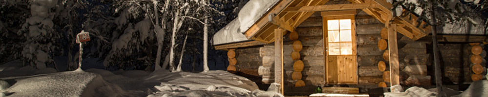
Farm Kota Accommodation
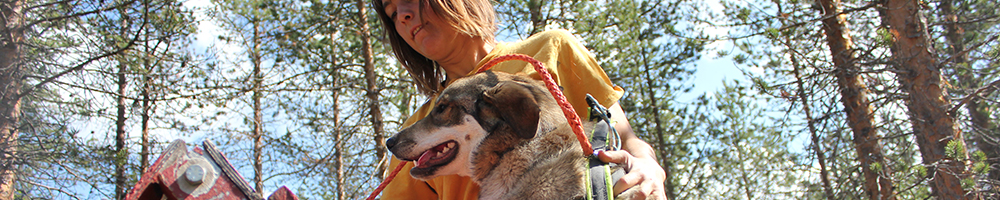
Our traditional farm 'kota' — a circular building with a central fireplace, where clients sleep on comfortable mattresses atop reindeer-skin benches — is often used the night before a multi-day safari starts, and on the first night of our 3- and 5-day tours. During the busy winter season we can rarely offer it to independent travellers, but outside the safari season you can stay on the farm for a behind-the-scenes glimpse of life on a working husky farm.
- Traditional kota in the middle of a 200-dog husky farm
- Reindeer-skin benches, underfloor heating, no running water
- Includes a farm tour and the option to walk the old dogs
- Per-person price drops with group size (up to 9)
Rustic but comfortable
This accommodation is rustic but comfortable. There are charging ports, underfloor heating and water for basic hand-washing, but no running water (no shower). The toilet is an outdoor one c.200m away near the farmhouse, as standard in Lappish wilderness settings. Sleeping bags and liners are included, though you may use your own. Since the kota sits in the middle of the c.200-dog farm, a guide will facilitate your experience.
What's included
The price includes a farm tour (€20 per person) and the option to walk old dogs (normally €35 per person), assuming you arrive early enough. You are welcome to brush dogs or help with feeding and bedding. Optional add-ons include a dog agility session, joining the evening feed, or bike-joring with the dogs. Breakfast and dinner — cooked over the open fireplace — are not included but can be requested ahead of time.
Meals & logistics
Continental breakfast includes porridge, cereals and bread. Dinner is normally a traditional Lappish meal of reindeer with mashed potato and lingonberries, or locally-caught white fish with rice and vegetables. Check-in is after 4pm (a bus stop is just outside the homestead); dinner is served by 7–7.30pm. Check-out is before 11am in summer and before 10am in winter.
- Price (1 person)
- €89pp
- Price (2)
- €79pp
- Price (4)
- €65pp
- Price (6)
- €55pp
- Price (7–9)
- €53pp
- Includes
- Farm tour (€20) + option to walk oldies; sleeping bags & liners
- Check-in / out
- After 4pm / before 11am (summer), 10am (winter)
Our Location: Finnish Lapland
Since we are 'off the normal grid', this section helps you orientate yourself relative to key Scandinavian towns and airports. The last leg to us is by air or road, as the closest train stations are a couple of hundred kilometres to our south. Most springs there are direct connections from Helsinki to Enontekiö, but these are often announced late.
- Only four roads run through the whole region
- Closest train stations are a couple of hundred kilometres to the south
- Last leg of the journey is by air or road
Only four roads
There are only four roads running through the whole region. One leads west to where the northernmost borders of Sweden, Finland and Norway meet and continues on towards Tromsø in Norway; en route, you can turn off towards Kiruna and Northern Sweden. The second road crosses the high tundra to our north before dropping down to Alta and the Arctic Ocean. The remaining two roads effectively head south, contouring around the borders of the line of fells that form the Pallas-Yllästunturi National Park. To our east lies nothing but pure wilderness for mile upon mile.
Enontekiö's National Park
The Pallas-Yllästunturi National Park is one of Finland's 37 national parks and is said by many to be the most stunning, thanks to the many ecosystem changes you pass through when walking its length. Finland's national parks are managed by Metsähallitus, the Ministry of Forestry, and are free to enter. They are extremely well maintained by European standards, all with open and bookable huts, some even with wilderness saunas.
- One of Finland's 37 national parks
- Often called the most stunning national park in Finland
- Free entry; managed by Metsähallitus
- Open and bookable huts, some with wilderness saunas
- Over 75% of Enontekiö is protected land
Protected land
National Parks are only one form of land protection in Finland. Indeed, over 75% of Enontekiö is protected land and, as such, the rugged and pristine nature is a paradise for nature lovers and those seeking relaxation in the pure air of the great outdoors.
Hetta-Pallas car transfer services
A number of companies, including ours, offer car transfers from one end to the other of the National Park for those planning to hike or ski its length. Ask for further details.
- Park
- Pallas-Yllästunturi National Park
- Entry
- Free
- Managed by
- Metsähallitus (Ministry of Forestry)
Nature-Based & Cultural Attractions
Enontekiö has 350 fells, 825 lakes, 200 kilometres of ski trails, 600 kilometres of snowmobile trails and 227 species of birds. Hetta is an age-old Lapp and Sámi dwelling place where traditional culture – centred on reindeer husbandry for the last few hundred years among both the original Lappish and the semi-nomadic Sámi inhabitants – is still very much alive. Natural livelihoods are still practised, handicraft skills passed down the generations, and the tradition of the Joiku (traditional Sámi lyric poems) continues to flourish.
- Age-old Lapp and Sámi cultural area centred on reindeer husbandry
- Living joiku (Sámi lyric poem) tradition
- Jyppyrävaara Hill look-out over Hetta and the fells
- Lake Ounasjärvi – source of the free-flowing River Ounasjoki
Living with the seasons
We live in firm connection with nature, and Lapland's 8 distinct seasons bring remarkable changes to daily life. Seasonal awareness matters in the arctic: the activities possible in our pristine nature vary as much with the seasons as does the rhythm of life on the husky farm. So choose wisely between deep winter, late winter, spring, early summer, summer, late summer, autumn and early winter.
Jyppyrävaara Hill and Lake Ounasjärvi
The best place to take in the uniqueness of the Hetta area's natural features is the look-out at the top of Jyppyrävaara Hill, where the village and surrounding fell landscape astound visitors time after time. The hill is covered by pine-dominated forest dotted with birch, aspen and mountain ash, with only a few lone spruce, as the northern growth line of spruce is 20 km south. Lake Ounasjärvi lies between the Pallas-Ounastunturi fell-chain and Hetta, and is the source of the River Ounasjoki, one of Lapland's longest free-flowing rivers.
- Fells
- 350
- Lakes
- 825
- Bird species
- 227
Facilities in Hetta, Enontekiö
There are plenty of tourist-related facilities and services in and around Hetta. More information about local businesses can be found in our 'Useful Links' pages.
- Hetta Hiihtomaa downhill slopes: 250-800 m long, plus a 100 m children's slope
- 100s of km of cross-country tracks around Hetta
- Full XC network open by mid-February
- Snowmobile rental available
- Car transfers across the National Park offered
Hetta-Pallas car transfer services
A number of companies, including ours, offer car transfers from one end to the other of the National Park for those planning to hike or ski its length. Ask for further details.
Downhill ski slopes and heliskiing
The ski slopes at Hetta Hiihtomaa are 250 to 800 metres long, and children have their own 100-metre slope and sledding hill. The slopes are the perfect steepness for learning to telemark or carve, and advanced skiers will find an abundance of wilderness slopes across Enontekiö. We have run several corporate heli-skiing programmes in the Kilpisjärvi region in the past, though northern Finnish helicopters are currently reserved for rescue and medical use.
XC ski track network
Hundreds of kilometres of tracks are open around Hetta in winter. The first are maintained as soon as the snow is deep enough; a wider network opens once the rivers and lakes have frozen securely; and by mid-February (the traditional Finnish skiing holiday) the whole network is open. Trails are groomed for as long as conditions stay good. Back-country skiers should also check out the Käsivärsi and Pöyrisjärvi Wilderness Areas.
- Downhill slope length
- 250–800 m (100 m children's slope)
- XC network fully open
- by mid-February
Summer Activities
The arctic is already well known for its winter activities, so here we highlight the region's summer potential, which is little known but almost limitless. Separate pages explain the difference between national parks and wilderness areas and outline the huge number of open and bookable huts you can stay in. We also cover paddling, hiking and biking separately, since in some areas the hiking and biking routes share the same trails while others have fairly strict mode-of-transport restrictions.
- Summer activities possible mid-June to end of September
- Mountains blossom through July and August
- Ruska (autumn colour) peaks in the first three weeks of September
- Mosquito-heavy roughly 20th June – 20th August (stay high)
Season and the ruska
The mountains blossom throughout July and August, and summer activities are possible from mid-June to the end of September (though between c. 20th June and 20th August you want to be on a fairly high trek because of the mosquitos). In autumn, particularly the first three weeks of September, the landscape turns vibrant with colour. This ruska period draws most of the Finnish 'summer' tourists – almost as many as visit in spring for the long warm days of skiing.
Karesuvanto
Between Kilpis and Hetta lies Karesuvanto, a destination for wilderness enthusiasts. Many visitors use it mainly as a base for fuel, coffee or lunch before leaving by boat or water plane for the Lätäseno river. The village hosts a Fly Fishing Contest in early August and 'ruska' markets in autumn, and the Arctic Canoe Race passes by.
- Summer season
- mid-Jun – end Sep
- Ruska period
- first 3 weeks of September
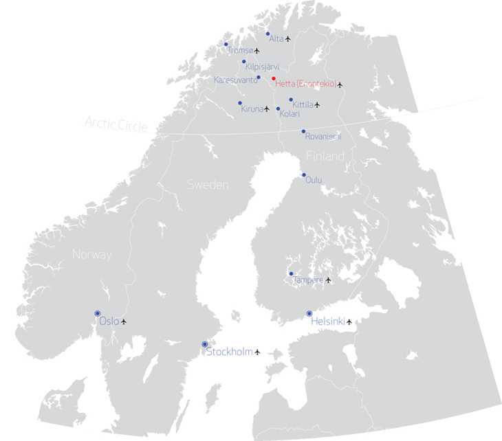
How to get to Hetta, Enontekiö
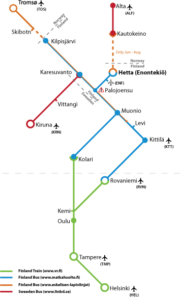
The schematic map shows Hetta's position relative to nearby airports and train and bus terminals in Northern Scandinavia. Despite being fully within the Arctic Circle, we are relatively easy to reach – the main complication, for those trying to save on travel costs, is that there are too many options.
- Enontekiö (ENF) airport: 10 mins away
- Kittilä (KTT): 2+ hours, buses twice daily – most hassle-free
- Rovaniemi (RVN): 4+ hours, main northern train terminal
- Alta (Norway): 2+ hours; Tromsø: 4+ hours
- New Arctic Bus Route connects the main northern Scandinavian cities
Choosing a route
If money is not an issue, or you book well in advance, flying into Kittilä or Rovaniemi in Finland and transferring by bus is the best option. You can sometimes save by comparing entry routes (Alta, Tromsø, Kiruna etc), though note that some overland bus and train connections are seasonal. For very last-minute bookings, charter flights are also worth checking, as they sometimes release seats to individual travellers.
Transfer times from northern airports & terminals
ENONTEKIÖ (ENF): 10 mins (airport shuttles available) – primarily open to charter flights; we are happy to pick clients up with advance notice.
KITTILÄ (KTT): 2+ hours (buses twice per day) – the closest commercial airport in Finland and the most hassle-free way of reaching us.
ROVANIEMI (RVN): 4+ hours (buses twice per day) – the main train terminal in northern Finland; a larger hub than Kittilä with more budget flight options. By bus the journey takes 5 hours door-to-door (c. 3.5 hours by hire car).
ALTA (Norway): c. 2+ hours, and TROMSØ: 4+ hours. A daily bus runs from Alta to Kautokeino (our closest Norwegian village, 1 hour from Hetta).
- Enontekiö airport (ENF)
- 10 mins
- Kittilä airport (KTT)
- 2+ hours
- Rovaniemi airport/train (RVN)
- 4+ hours
- Alta, Norway
- 2+ hours
- Tromsø, Norway
- 4+ hours
Useful Links
A collection of useful links covering our own websites and social channels, our tour-operator partners, and practical local area information for when you are in Enontekiö.
- Facebook – regular farm, dog and guide updates
- YouTube channel with farm videos
- CAPE Lapland – polar / survival courses (in development)
- Tour partners: Campfire Adventures, Timetours, Aventure Arctique, Spice UK and others
- Local: vet in Hetta most days; Minna's Reindeer Farm; Hetta Hiihtomaa ski centre
Our websites
Facebook is the best place for regular updates about our farm, dogs and guides. Our YouTube channel hosts both polished farm videos and fun clips. The CAPE Lapland website (still in development) will feature our more extreme 'polar' / 'survival' courses and products, while the Hetta Huskies site focuses on our dog-sledding and husky farm products.
Our tour operator partners
We cooperate with a number of companies internationally who extend the reach of our product portfolio by advertising our products in their markets. They include, but are not limited to: Campfire Adventures, Timetours, Fintouring, Finstours, Aventure Arctique, Spice UK and Student Adventures.
Useful area information
There is a vet in Hetta most days of the week and the Muonio practice is open most Tuesdays. Päivi Nilimaa in Ylimuonio (040 568 8092) is the dog rescue person for that area. Hetta Hiihtomaa, Hetta's ski centre, has a website with information about the ski track network and downhill skiing. Enontekiö is the starting point for information about local businesses and events, and Tosilappi is the tourist-focused website for our area. Minna's Reindeer Farm is a useful link for those interested in reindeer sleigh rides and farm experiences close to Hetta.
When to Come
There is plenty to do at our farm year-round, but from a dog's perspective there are four distinct seasons: 1) the Mushing Season, c. November to end April; 2) the Spring Training Season; 3) the Summer Season; and 4) the Autumn Training Season. Locals say there are actually 8 distinct arctic seasons, which is pretty accurate. Each brings its own challenges and rewards.
- Mushing Season: c. November to end April
- Sledding can start as early as October
- Full short-safari route range open by mid-December
- Longer multiday safari routes open from early January
- Locals count 8 distinct arctic seasons
Early Mushing Season
We might be sledding as early as October or as late as end November. At first we run only a few safaris: the first route opened each season is a 5km loop close to the farm, and the next to open depend on whether ice or snow conditions are better. By mid-December at latest the full range of short-safari routes is open. In early January we begin opening the longer Multiday Safari routes – we call weeks 2-5 'Early Winter Trail Blazing'. Multiday safaris at this time mean challenging arctic conditions: little light, unconsolidated trails and tough going.
Mid-Winter Mushing Season
We call weeks 6-9 the 'Frosty Depths of the Arctic Winter'. The picture-perfect arctic (snow-laden trees etc) is still likely at the start of February, but conditions are harder to predict: the cold can be even more intense than early season, or mushing can be fairly easy. At least one week in February tends to be very cold, and at least one tends to bring the last huge dump of snow.
Spring Mushing Season
By week 10 we enter the Spring Mushing Season – a fun time to mush, as the snow crystallises underfoot and other users consolidate the trails. Everything gets a little easier, letting guides and dogs recover and giving customers a real chance to enjoy the dogs and each other at the end of their days.
- Mushing season
- Nov – end Apr
- First route each season
- 5 km loop near the farm
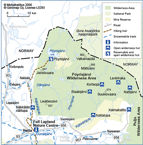
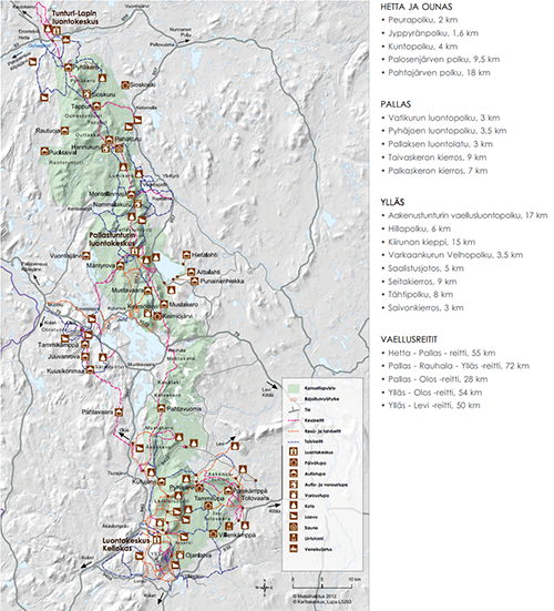
Wilderness Areas in Enontekiö
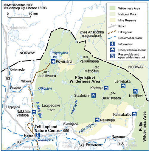
Enontekiö is a wild, ancient and uninhabited Lapland of vast wilderness areas, free-flowing rivers and Finland's only high fell area – rugged, pristine nature that is a paradise for nature lovers seeking the pure air of the great outdoors. Over 75% of the area is protected land, and 60% of all Finland's fell highlands are found here, including every fell over 1000m high. Enontekiö also has numerous wilderness areas and one of Finland's 37 national parks, the Pallas-Yllästunturi National Park.
- 60% of all of Finland's fell highlands are here
- 40 fells over 1000m high, including Halti (1324 m), Finland's highest
- Over 75% of the area is protected land
- Finland's only high fell area, with free-flowing rivers
- Major wilderness areas: Pöyrisjärvi, Tarvantovaara, Pulju, Käsivärsi
The high fells
There are 40 fells over 1000m high, including Halti (1324 m), Ridnitsohkka (1316 m), Ruvdnaoaivi (1239 m), Kiedditsohkka (1200 m), Urttasvaara (1200 m), Kovddoskaissi (1200 m), Loassonibba (1190 m), Pihtsosjunni (1160 m), Saana (1029 m) and Toskalharji (1026 m), among many others. Halti is Finland's highest mountain.
Remote and relatively unknown
Although the Pallas-Yllästunturi National Park has long been a popular Finnish outdoor destination, most of the area remains fairly remote and relatively unknown. The major wilderness areas around Enontekiö include Pöyrisjärvi, Tarvantovaara, Pulju and the Käsivärsi (the 'Arm' of Finland) around Kilpisjärvi.
- Fells over 1000m
- 40
- Highest fell
- Halti, 1324 m
- Protected land
- over 75% of Enontekiö
Winter Area Attractions
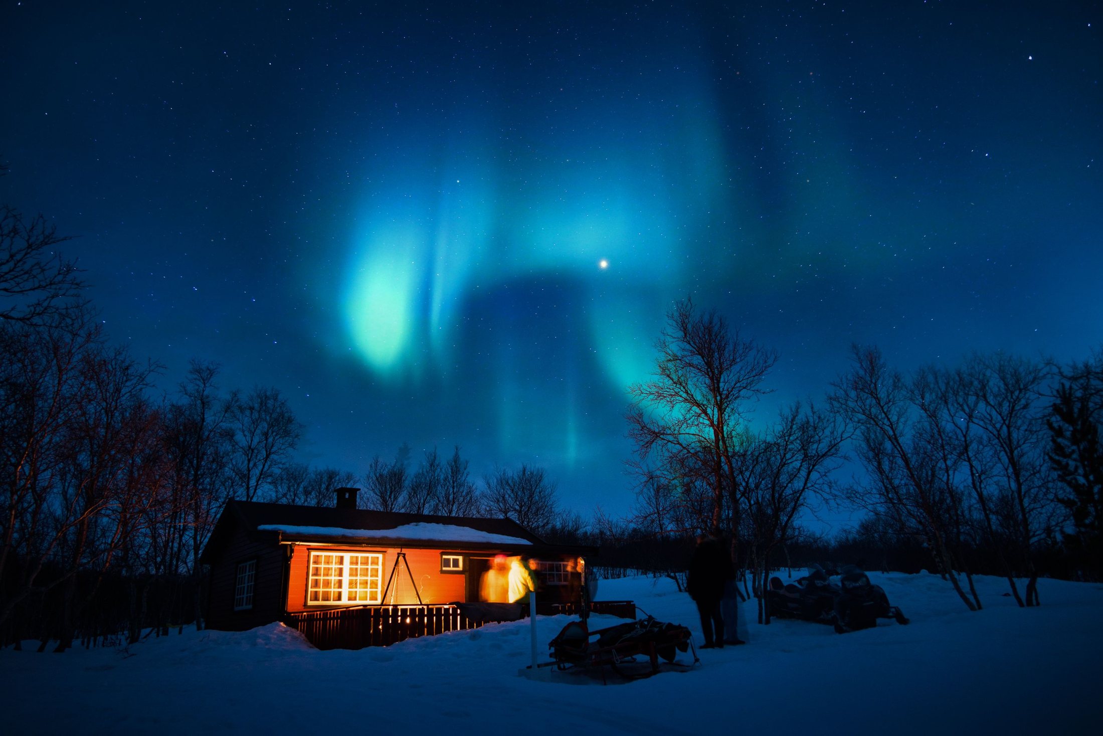
Enontekiö is said to have the purest air in Europe, along with 8 distinct seasons, 62 days of midnight sun and 200 days of 'winter'. For skiers this means the longest skiing season in Finland; for those chasing the ephemeral northern lights, they appear c. three nights out of four and can be seen on clear, dark nights for many months of the year.
- Longest skiing season in Finland
- Northern lights c. three nights out of four
- Norway, Sweden and the Arctic Ocean only a day-trip away
- Taiga gives way to high tundra just 20km north of base
A unique mix of terrain
We have a unique mix of terrain. At the northern edge of Europe's great boreal forests, the taiga gives way just 20km north of our base to high tundra and exposed, treeless arctic plateaus. Enontekiö sits at the intersection of three national borders – Norway, Sweden and the Arctic Ocean are only a day-trip away.
The great fells
The great fells of Enontekiö, such as Saana and Malla in Kilpisjärvi, stand watch over the nation's oldest nature reserve and form part of the national landscape. Even on the Lappish scale, this legendary great fell region offers more than other areas can dream of.
- Northern lights frequency
- c. 3 nights out of 4
- Days of 'winter'
- 200