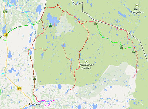
There are three main variations on the classic Poyrisjarvi traverses, plus a demanding 104km day trip option which goes from Hetta to Kalgujarvi to Kivilompolo — a 10-hour day which starts with 17km of asphalt between Hetta and Vuontisjarvi, then takes the quad bike trail to Kivilompolo.
- 118km Kalma-Termis-Nakkala wilderness traverse for expert riders
- 104km Hetta-Kalgujarvi-Kivilompolo day trip — a demanding 10-hour ride
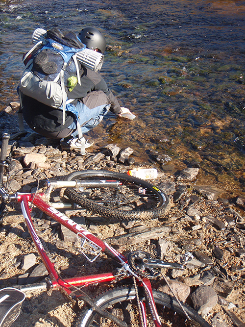
- Unmarked trails: bring map, compass and proper clothing; rivers crossed by wading
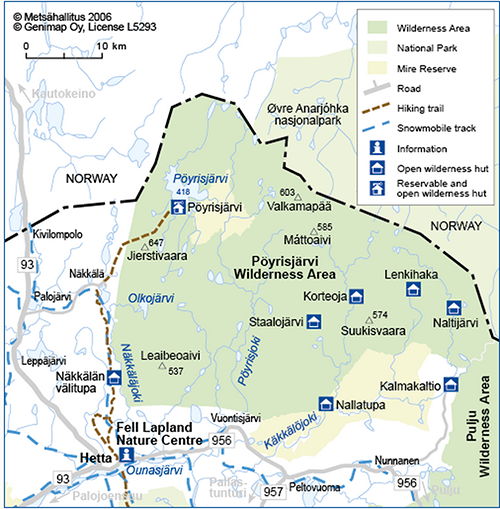
- Metsahallitus wilderness cabins at Poyrisjarvi and Naltijarvi (some bookable)
- Routes cross the Norway–Finland border — carry your passport
Wilderness Trails in Poyrisjarvi
The three classic traverses are: Kalmakaltio-Termis-Nakkala (118km) and Kalmakaltio-Poyrisjarvi-Nakkala (c. 93 km), both for expert riders; and Kalmakaltio-Naltijarvi-Kalkujarvi-Poyrisjarvi (75 km). The Poyrisjarvi trails are unmarked but generally clearly visible in the terrain. There are no service structures, rivers must be waded and weather can change suddenly, so you must be fairly self-sufficient and carry a map, compass and proper clothing if entering this region.
Services
Metsahallitus maintains wilderness cabins at Poyrisjarvi and Naltijarvi, and cabins can also be hired at Poyrisjarvi. On its western side, the Lenkihaka open wilderness hut may be useful. The villages of Nunnanen, Kalmakaltio and Nakkala offer lodging before or after the trek. The spacing between huts means a long, committing day in the middle of the journey.
Kalma-Termis-Nakkala (118km)
The 118km Kalma-Termis-Nakkala and c. 93km Kalmakaltio-Poyrisjarvi-Nakkala trails are best suited to expert riders. The 118km route is relatively easy to find, since parts are quad-bike trails following the northern reindeer herding routes near the Norway-Finland border. It traverses towards Poyrisjarvi, then turns south through the sand dunes of Maater and past Termisvaara Lake to the south side of Nakkala. If you take the trail south of Poyrisjarvi Lake, note that it follows the shore for 2km and can be almost impassable in storms; even in good weather you must wade the Poyris River.
Poyrisjarvi – Nakkala
Although the normal 118km trail continues north to the border, an alternative 10.6km route breaks off at Sahpanpalo for the SW shore of Lake Poyrisjarvi. From Poyrisjarvi, an unmarked but clearly visible 18km trail runs to the village of Nakkala; people often ride it as a 36km Nakkala-Poyrisjarvi-Nakkala day-trip. A more southerly option is the 24km (+15km) Nakkala-Ainuppivaara-Poyrisjarvi expert trail, which climbs immediately to the hilltop through sand dunes and fell scenery.
Crossing the Border
Approaching Nakkala along the standard northerly 118km trail, several options arise west of Lake Poyrisjarvi. You can follow the 6km trail north of Termisvaara parallel to the border fence, or head north into Norway towards Siccajarvi (8km), where a Fell Station offers paid overnight stays. From Siccajarvi it is a 14km tractor road to the main asphalt road, then another 20km to Kautokeino. Alternatively, bike due west for 15km on the Raja-Kivilompolo trail, with its many boardwalks and bridges across bogs and streams.